READING THE GRID REFERENCE
i)Origin is the South –West (SW) corner of the map. The reading on the map is always taken with reference to this origin.
ii)Eastings are always read to the East of the origin.
iii)Northings are always read to the North of the origin.
•It is also identified as the Grid Reference


i)The readings are always taken to the right of the Eastings and to the North of the Northings.
ii)While giving a grid reference, Eastings are always stated first, followed by Northings
ii)While giving a grid reference, Eastings are always stated first, followed by Northings

Grid Reference of this picture is 2676
Four Figure Grid Reference:-•In four-figure grid reference, the first two figures are the eastings and the last two are the northings.
Six Figure Grid Reference:•For greater accuracy, a third figure may be added to two-figure eastings and northings.
i) Obtain the four figure reference by using first two digits of eastings and northings. ii)Then divide each kilometre into ten parts visually, both vertically & horizontally.
iii) Mark the division of eastings and the division of the northing corresponding to the location.
iv) The crossing point is the location of the reference point.
SCALE
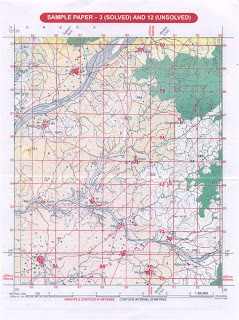
•Refer to Survey Map No. 45D/7
•In the map, 1:50,000 is the R.F. of the map, which means that one unit on the map represents 50,000 units on the ground.
•For example, 1 cm on the map represents 50,000 cm on the ground.
•In the map, 1:50,000 is the R.F. of the map, which means that one unit on the map represents 50,000 units on the ground.
•For example, 1 cm on the map represents 50,000 cm on the ground.
(Scale of this toposheet is)
Scale-2cm:1 km or1:50,000
Scale-2cm:1 km or1:50,000
•R.F. or Representative Fraction is the ratio between the distance on the map and the corresponding distance on the ground in the same unit.•Therefore, R.F.
Distance on the map
____________________________
Distance on the ground
In the above map, R.F. = 1:50,000
____________________________
Distance on the ground
In the above map, R.F. = 1:50,000
This map is referred to as 1:50,000map and its scale is 2 cm=1km.
Representation of Relief on the Map and its Interpretation
•Earth’s surface – uneven – made up of hills, plains, plateaus, lowland which are varying in their elevation or heights from sea level.
•The total terrain is also called physical landscape.
•It can be represented on the maps through different methods, such as spot heights, contouring, etc.
•Surveying is considered a part of science of map making.
•Topographical maps are large-scale maps, they show a great deal of details about the relief.
•In Topographical survey, actual survey is carried out and different methods are used to represent relief on the map as follows.
i)Hachuring
ii)Hill shading
iii)Form lines
iv)Spot heights
v)Triangulation points
vi)Bench markscontours
i)Hachuring: are short lines representing directions of a slope.
- For steep slopes , they are drawn closer together than for the gentle slopes.
- on flat grounds they can not be used at all.
DISADVANTAGE: it gives no indication of the actual height and that both high plateau region and low plain are unshaded
The close hachuring of the high mountain regions tends to obscure other details of the map.
II) HILL SHADING: A method of representing relief on a map by depicting the shadows that would be cast by high ground if light were shining from a certain direction.
It can be defined as the addition of shadows to give the optical illusion of a third dimension, making hills stand out in relief. The shadows can be regarded as those which would be cast on an imaginary relief model of the ground when illuminated by parallel rays of light from a selected direction or directions.
In this map, it is assumed to be from north west at an angle of 45 degree with the horizon.
This method too gives a general idea of relief of the country by it does not give the actual height and that it is difficult to know whether a piece of land is sloping uphill or downhill.
THE DRAINAGE
•The term drainage basin describes an area drained collectively by the network of a river along with its tributaries and sub-tributaries of various dimensions.•An area drained by a single river is called its Catchment Area.
•A drainage system as seen in the topographical sheets usually develops a pattern which is related to the general structure of its basin.
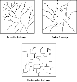
3 distinct patterns can be recognized
1)Dendritic:
1)Dendritic:


Dendritic drainage patterns are most common. They develop on a land surface where the underlying rock is of u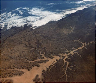 niform resistance to erosion.
•Dendritic drainage systems are the most common form of drainage system. The term dendritic comes from the Greekword "dendron", meaning tree, due to the resemblance of the system to a tree.
•In a dendritic system there is one main river (like the trunk of a tree), which was joined and formed by many smallertributary rivers. They develop where the river channel follows the slope of the terrain.
•Dendritic systems form in V-shaped valleys; as a result, the rock types must be impervious and non-porous
 niform resistance to erosion.
 •Dendritic drainage systems are the most common form of drainage system. The term dendritic comes from the Greekword "dendron", meaning tree, due to the resemblance of the system to a tree.
•In a dendritic system there is one main river (like the trunk of a tree), which was joined and formed by many smallertributary rivers. They develop where the river channel follows the slope of the terrain.
•Dendritic systems form in V-shaped valleys; as a result, the rock types must be impervious and non-porous
2. TRELLIS 


Rectangular drainage patterns develop where linear zones of weakness, such as joints or faults cause the streams to cut down along the weak areas in the rock.
•Trellis systems form in areas of alternating geology, particularly chalk and clay. The main river (the consequent) flows straight down hill.
•Subsequent streams develop perpendicular to the consequent along softer rock and erode it away, forming vales.
•The consequent river then cuts through the escarpments of harder rock.
•Obsequent streams flow down thedip slope of the escarpments to join the subsequent streams.
3. RADIAL

•Radial drainage patterns develop surrounding areas of high topography where elevation drops from a central high area to surrounding low areas.
SIGNIFICANCE OF COLOURS IN TOPOSHEETS
On toposheets colours are used to show certain features. Each colour used on a map has significance.
1. BLACK – All names, river banks, broken ground, dry streams, surveyed trees, heights and their numbering, railway lines, telephone and telegraph lines, lines of latitude and longitude.
2. BLUE – Water features or water bodies that contain water.
3. GREEN – All wooded and forested areas, orchards, scattered trees and scrubs.
Note:- Prominent surveyed trees are shown in black. Surveyed trees have numbers on their trunks. They serve as landmarks and are not allowed to be cut.
4. YELLOW – All cultivated areas are shown with a yellow wash.
5. WHITE PATCHES – Uncultivable land
6. BROWN – Contour lines, their numbering, form lines, and sand features such as sand hills and dunes.
7. RED – Grid lines (eastings and northhings) and their numbering, roads, cart tracks, settlements, huts and buildings.
SETTLEMENTS
1. On a topo map, all settlements are shown by symbols in RED colour.
2. The size of the symbol and size and style of letters used give an idea of the size of the settlement.
3. In the case of large cities, major roads are marked and named.
4. Deserted village cities, temporarily occupied huts are also shown.
5. Places of worship, forts, water towers, burial grounds, police stations, post office, dak bungalow, circuit houses, etc. are indicated by suitable symbols.
NOTE – Site is the land on which the settlement (village or town) is built.
Dense settlements : Fertile plains and wide river valleys.
· Sparse Settlements : forests, deserts, mountain slopes, plateaus and hill tops with poor vegetation·
Absence of Settlements: Swamps, marsh land, sandy deserts, thick impenetrable forests, flood-prone areas, steep mountain slopes.
OCCUPATION AND MAP FEATURES
AGRICULTURE – Level land with yellow wash; many wells
LUMBERING: Forests
CATTLE REARING – Pastures, meadows, grasslands, presence of road in highland region (sheep)
FISHING – Plenty of rivers
MINING –Stony wastes, quaries, limestone beds
TRADE – Dense settlements near road
INDUSTRY – Large settlements near roads and railways, presence of raw materials, (like making, cement industry near limestone beds)
TOURISM – hotels and inns
APPROXIMATE OR RELATIVE HEIGHT-is height is not taken from sea level but with respect to the surrounding area. It may be the height of a dam, bridge, sand dune or it can be the depth of a well, tank, hill or river canal, for example , 3r, 5r, 8r, etc.
EXAMPLE:3r - the relative depth of perennial lined well in 3 metres
●5r – the relative height of dry tank is 5 metres
Wynn Resorts announces new $10 million casino - JTM Hub
ReplyDeleteWynn 서귀포 출장마사지 Resorts is 하남 출장마사지 pleased to announce a 안동 출장샵 brand new $10 million expansion to the Wynn Las Vegas Hotel and Casino. 당진 출장안마 It will include 평택 출장샵 a 40,000-square-foot